It shouldn’t rain for days in February this far north. The sea ice shouldn’t turn to slush. People shouldn’t fall through the ice by the dozen. For the residents of the Inuit community of Nain, Nunatsiavut, Labrador’s northernmost permanent settlement, this was the new reality greeting them in 2010. The sudden thaw made people wary of travelling by snowmobile to collect firewood or hunt. Encrusted in ice, a communications tower collapsed, leaving residents without internet and phone service. Flights carrying food supplies couldn’t land because of thick fog.
Skip to content
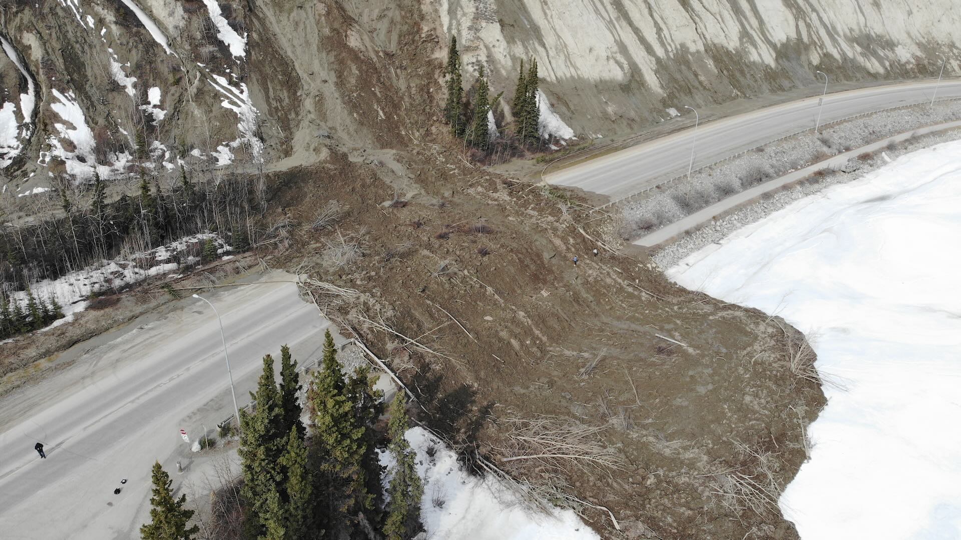 In spring 2022, a landslide in Whitehorse sent some 2,000 cubic metres of mud rushing down, blocking a major road for five weeks. Photo: City of Whitehorse/Handout
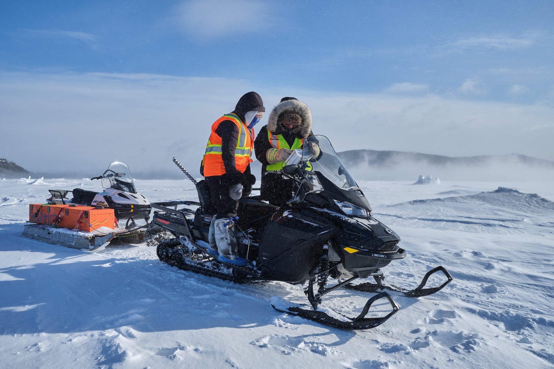 First tested in 2013, SmartICE—as the organization is known today—now operates in nearly 40 communities across Canada's North. Photo: SmartICE/Handout
The Big Read
In Canada’s North, communities reckon with a melting world
For generations, Inuit have used traditional knowledge to navigate a frozen world. Now, northern-made technology is helping them thrive amongst a rapidly thawing landscape.
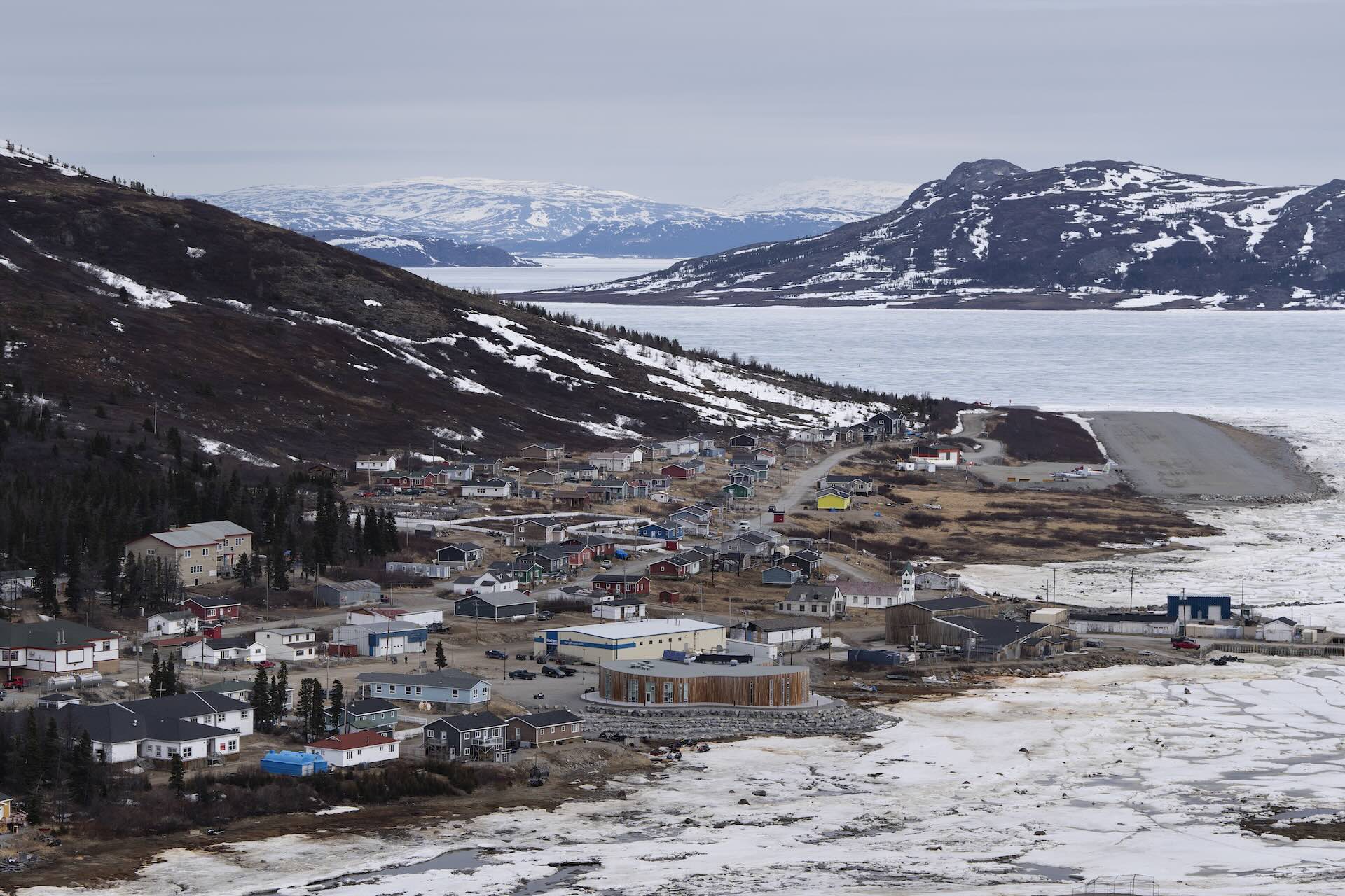
The view from Mount Sophie of the Labrador Sea and the town of Nain, N.L. The community is one of many in Canada’s North facing the impacts of climate change. Photo: The Canadian Press/Darren Calabrese
It shouldn’t rain for days in February this far north. The sea ice shouldn’t turn to slush. People shouldn’t fall through the ice by the dozen. For the residents of the Inuit community of Nain, Nunatsiavut, Labrador’s northernmost permanent settlement, this was the new reality greeting them in 2010. The sudden thaw made people wary of travelling by snowmobile to collect firewood or hunt. Encrusted in ice, a communications tower collapsed, leaving residents without internet and phone service. Flights carrying food supplies couldn’t land because of thick fog.
Talking Points
- Across Canada’s North, the climate crisis is rapidly and radically changing everyday lives. Permafrost is thawing, sea ice is disappearing and, in the summer, wildfires are raging.
- Ice travel is integral to life in the Arctic, yet a warming world is making sea ice conditions unpredictable
- In response, communities in Canada’s North are combining traditional knowledge with technology to continue to thrive in remote locations. Innovative new sensors and trackers are helping to monitor conditions even in the most remote locations.
The situation represented a new normal, of sorts, in a region that is normally frozen solid through the winter. In response, the Nunatsiavut government started looking at ways for the community to continue to thrive even as the climate changed. One of the experts it turned to was Trevor Bell, then a geography professor at Memorial University in Newfoundland. The goal was to use technology to help people safely venture out onto the ice as the climate crisis affected millennia of knowledge about how ice forms and behaves.
In years past, the ice in Nain was typically thick enough for snowmobile traffic from December to May and sometimes as late as June. In the spring, locals knew to avoid polynyas, locally known as rattles, which are areas of open water, surrounded by ice. As the ice started to melt, puddles would form on the ice, then the water would drain through the holes that naturally opened up. Typically, there’d be three such drains every spring.
Now, though, the sea ice was forming later, often not until late January, wasn’t growing as thick, and was melting earlier. Some of the spring rattles were now present all winter. And instead of three drains, only one was happening.
Bell’s solution, developed with the Nunatsiavut government and Christian Haas, a sea-ice scientist, was twofold. The first element was SmartBUOY, a stationary sensor that’s inserted into the ice to measure thickness; the second was SmartQAMUTIK or SmartKAMUTIK, a mobile device pulled behind a snowmobile that measures snow and ice by transmitting electromagnetic signals that induce electrical currents in the salt water below. The system would be Indigenous operated, with data uploaded to SIKU.org, an Indigenous knowledge-sharing website.
Related Articles
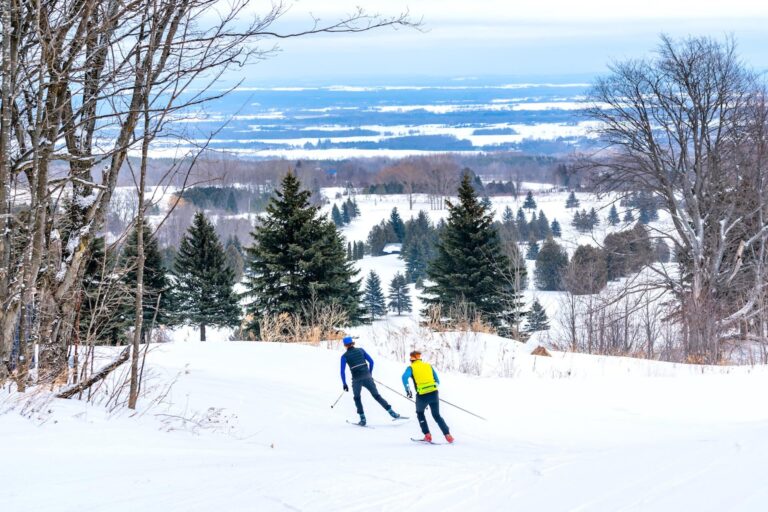

First tested in 2013, SmartICE, as the organization is known today, now operates in nearly 40 communities across Canada’s North. It’s run as a social enterprise with a majority Indigenous board and trains local residents to operate the tools and collect the data. “Our technology should never replace Indigenous knowledge of safe ice travel,” Bell says. “Traditional knowledge is what ultimately allows Indigenous communities to adapt to changing climate or other stressors, but certainly our technology augments that Indigenous knowledge.”
For thousands of years, Inuit have navigated ice travel using Inuit Qaujimajatuqangit—traditional knowledge and culture. They share experiences and guidance with younger generations, such as which areas are typically safe for travel and which aren’t, the ways in which the ice freezes up in the fall and melts in the summer, and how to test ice thickness by striking it with a harpoon or an axe. In both Nain and Pond Inlet, or Mittimatalik, in Nunavut, for example, the local knowledge is that if your harpoon doesn’t go through after two blows, the ice is safe for walking. If it withstands three, the ice is safe for snowmobiles.
This intimate understanding and awareness accompanies a detailed terminology to describe specific conditions. In Nain, for instance, apitainnak means snow covering open water, where the ice is not very frozen—very dangerous. In Igloolik, Nunavut, sikuvik refers to solid ice that’s about one foot thick, with some snow accumulation, and can be travelled upon.
In the Arctic, ice travel is integral to the way of life. “We travel on it to go to our camping grounds, hunting grounds, even travel to our neighbouring community to see our friends or family,” says Andrew Arreak, a resident of Mittimatalik. “It’s also a part of our identity.”
As SmartICE’s Nunavut operations lead, Arreak trains people to use the technology. In Mittimatalik, SmartICE helped residents enjoy their longest ice-travel season on record in the winter of 2022–2023, despite the changing conditions. The monitoring and mapping doesn’t just reveal where the ice is thin, it also shows where it’s thick, allowing people to travel for a longer window of time than they had in decades. It’s also helped reduce the number of search-and-rescue operations for people who’ve fallen through the ice.
Across Canada’s North, the climate crisis is rapidly and radically changing everyday lives. In Whitehorse, Robert Service Way, a major thoroughfare, has been affected by multiple landslides in the past three years. In spring 2022, one slide sent some 2,000 cubic metres of mud rushing down, blocking the road for five weeks. Smaller slides followed in 2023 and 2024, prompting Laura Cabott, Whitehorse’s then-mayor, to declare such events “a new reality” as she and Harjit Sajjan, then the federal minister of emergency preparedness, announced a $45-million plan to move the road away from the sloughing escarpment.
In the meantime, a network of northern-made sensors, developed by local firm Kryotek, gathers data on the area. The system is the brainchild of Jim Coates and Astrid Grawehr, two Yukon-raised geographers who specialize in how climate change is affecting northern landscapes—and how technology can help residents, governments and businesses adapt. More than 60 of the company’s Bluetooth ErosionAlert sensors—each about the size of a poker chip—are located at the top of the most active slides and buried in the earth. They’re connected to over a dozen satellite transmitters, which resemble a thick cell phone with a solar panel. When soil along the clay cliffs moves, the sensors, which are still in advanced testing, send real-time notifications.
Canada’s North is warming at about three times the global rate, leading to a dizzying range of environmental changes—permafrost is thawing, sea ice is disappearing and wildfires are raging. In the summer of 2023, the Northwest Territories experienced “unprecedented conditions” that led to 306 wildfires raging across the territory, burning more than 3.4 million hectares. The annual ice bridge across the Yukon River in Dawson City, which connects two small off-grid neighbourhoods to the main townsite, has become less reliable in recent years due to inconsistent temperatures. Nunavummiut are also witnessing changes in wildlife behaviour, from caribou migrating to different areas to seals with lower fat content, which affect food security in the territory.
The impacts of these changes are far-reaching, from the health and safety of residents to increased infrastructure spending, as roads crack and collapse and building foundations sag. Technology can only help so much, according to those working to help people in Canada’s North live more safely. What’s most important, they say, is that solutions are informed by northerners’ experience.
Coates has first-hand experience with how dangerous extreme weather events in the North can be. In 2005, he was working on his master’s degree at the University of Ottawa, studying the effect of forest fires on permafrost and landslides in the Yukon. As he drove through the gold fields near Dawson City early one morning, near his study area, he approached a culvert over a tributary to the Indian River. It was foggy, but he could see what looked like a large puddle ahead, left over from a thunderstorm the night before.
It wasn’t a puddle. Heavy rain the night before had washed out the culvert and Coates drove straight into the water, submerging the cab of his truck. Shaken but unharmed, he crawled out the back window and walked a few kilometres to the nearest mining camp to get help pulling his truck out. “That one incident, which could have been much worse than it was, made me realize that instant alerts of climate damage to infrastructure are absolutely critical,” Coates says.
It provided the spark for ErosionAlert, which is now being used across the North, including in Old Crow, the Yukon’s northernmost and only fly-in community; Tsiigehtchic, a Gwich’in community in the northern Northwest Territories; along the Dempster Highway; and on an exploration access road in the Mackenzie Mountains.
For a time, Coates and Grawehr were focused on creating sensors for climate-change adaptation through their company Kryotek. They also worked on FrostLink, a permafrost-monitoring instrument and explored wildfire-detection tools. But then they realized there were a plethora of environmental sensors already on the market. The real problem was communication. It’s challenging to get sensors to collect and transmit data, especially in cold, remote environments with little to no cellular connectivity. Solar-powered batteries don’t work so well when it’s dark for months at a time.
Coates and Grawehr, partners in life and business, pivoted. How could they make it easier for people to get the information they needed from sensors? Grawehr says the majority of sensors in Canada, whether they be for engineering, permafrost monitoring or frost management, are data loggers. To collect the information, a human must travel to the sensor, often in a helicopter or float plane due to the remote location, use a USB cable to connect it to a computer, and off-load the data. Then you need to put that data into a spreadsheet, analyze it and review the results. Not very efficient, especially if you need to find out whether a road is at risk of collapsing.
Satellite-connected platforms—which aren’t reliant on cell service or Wi-Fi—exist, but they’re clunky and technical. Coates and Grawehr wanted to make something nimble that would readily display information online. They asked Whitehorse tech company Make IT to build them a software platform that would allow most sensors—including Kryotek’s—to communicate with Iridium satellites, a network that’s further into space than Starlink satellites and uses less power.
The collaboration went so well that Coates and Grawehr decided to form a new company with Make IT called DeltaVue, whose goal is to connect satellite-to-sensor systems not just in the North but all over the world. In essence, their system makes it so most sensors with Bluetooth can communicate with Iridium. Along the way, the two geographers inadvertently became well-versed in satellite communications.
Though the couple set out to solve a uniquely northern problem, and most of their clients are based in the North, DeltaVue is also getting international interest, from flood-detection efforts in South Carolina to environmental monitoring at mines in Bolivia. The company’s northern origins have helped affirm for them the value and function of their technology. “If you can make something work in Old Crow, you can make it work anywhere,” Coates says.
As the climate crisis worsens, the technology needed to monitor it is changing, too. SmartICE is developing a drone that uses electromagnetic technology to detect and measure slush sitting on top of sea ice, a growing safety concern in the North. With thinner ice and more precipitation, snow weighs down the ice so seawater gets pushed up between the ice and the snow. Driving into slush on a snowmobile is a recipe for getting stuck. These custom-built drones would collect data without putting a SmartQAMUTIK operator at risk.
With National Research Council Canada funding, the organization is also working on a radio-frequency ice-thickness sensor for snowmobile trails on lakes and rivers. Ground-penetrating radar is useful on ice bridges and ice roads, where the snow has been plowed away, but it’s not as effective on snow-covered trails. And while the SmartQAMUTIK works on salt water because of its conductivity, it doesn’t work on freshwater.
“As a social enterprise, we’re always responding to community priorities,” Bell says. This extends beyond technology development. In addition to hiring and training locals, SmartICE also opened a technology production centre in Nain, so its tools could be made in the North, by northerners.
Communities don’t pay for SmartICE—the organization is funded via a blend of money from governments, industry and organizations. The goal, Bell says, is to step away from how research has traditionally been done in the North: southern researchers parachuting in, collecting their data, then heading back to their universities—not considering that northerners, especially Indigenous northerners, know better than anyone what’s happening on the land.
“If we, as a society, are to understand and design pragmatic solutions to climate change, Inuit need to be at the forefront of the research and decision-making process,” wrote Inuk consultant Pitseolak Pfeifer in Yukon University’s Northern Review in 2020. “Our capacity and evidence needs not to be legitimized, but rather seen as a unique asset in approaching climate change in an integrated, applied, holistic manner.”
In Arctic Bay, also known as Ikpiarjuk, a community on northwest Baffin Island in Nunavut, a local tourism company doubles as a SmartICE operator. Roughly every week, one of Arctic Bay Adventures’ Inuit guides spends eight hours driving a SmartQAMUTIK across frozen Admiralty Inlet. The resulting route map gets circulated in the community, but it’s also useful for the tourism business, which is owned by the hamlet of 900 people. Arctic Bay Adventures offers trips by boat in the summer and by dog team and snowmobile throughout the rest of the year.
“We use the readings to make sure that when we set up base camps in May and June that they’re on good, solid ice with no chance of drifting off to Greenland,” says general manager Chris Mitchell. The guides’ deep knowledge of the area informs their work, and the SmartICE data helps. Does the technology make people in the community feel more confident going out on the ice? “More confident when the whole paradigm of being on the land is changing,” Mitchell says, before pausing. “Less concerned, shall we say, instead of more confident.”



Loading...
Thanks for sharing!
You have shared 5 articles this month and reached the maximum amount of shares available.
CloseThis account has reached its share limit.
If you would like to purchase a sharing license please contact The Logic support at [email protected].
CloseGift the full article!
You have gifted 0 article(s) this month and have 5 remaining.
Recipients will be able to read the full text of the article after submitting their email address. They will not have access to other articles or subscriber benefits.
Photo: The Canadian Press/Darren Calabrese
In spring 2022, a landslide in Whitehorse sent some 2,000 cubic metres of mud rushing down, blocking a major road for five weeks.
First tested in 2013, SmartICE—as the organization is known today—now operates in nearly 40 communities across Canada's North.
Most Popular This Week



In-depth, agenda-setting reporting
Great journalism delivered straight to your inbox.
News
People hired to promote Canadian rocket firm didn’t actually help, company alleges in lawsuit defence
Briefing
New 100% U.S. tariffs on drones take effect, hitting Canadian industry
Solomon says Canada will stick with its own AI rules after U.S., tech giants push G20 not to regulate
Ottawa defence supplier Allen-Vanguard put into receivership
Best business newsletter in Canada
Get up to speed in minutes with insights and analysis on the most important stories of the day, every weekday.
Exclusive events
See the bigger picture with reporters and industry experts in subscriber-exclusive events.
Membership in The Logic Council
Membership provides access to our popular Slack channel, participation in subscriber surveys and invitations to exclusive events with our journalists and special guests.