Listen Now
0:00
OTTAWA — With everything from smartphone map apps to crop planting to stock trades relying on American Global Positioning System (GPS) satellites, Canadian space and military leaders want Canada to have its own replacement for fragile technology run by a potential adversary.
“If Canada loses access, through any means, to the current position, navigation and timing system, it could cost the Canadian economy up to $1 billion a day,” Mike Greenley, chief executive of Canada’s space-sector giant MDA, said in an Ottawa speech last month.
Canada should have an alternative to the system, he said, which has been maintained by the United States since the U.S. launched it in 1973.
Talking Points
- GPS signals are dead easy to jam, possible to spoof, not that precise, barely functional in the far North—and completely dependent on American technology
- The Department of National Defence has poured millions of dollars into researching alternatives, and private enterprise is coming up with satellite constellations of its own
Simply being able to tell where we are is a capability as important as monitoring our borders, Greenley said: “It is an operational imperative to make sure that we have security and sovereignty over our whole country, and that we have the capability to contribute to allied operations globally beyond Canada.”
The numbers vary as new satellites go up and old ones are decommissioned, but now about 32 GPS satellites circle Earth in orbits about 20,000 kilometres up, beaming down low-power signals indicating their precise locations and times. A receiver, like a smartphone, takes in several of those signals at once and uses the data to calculate where on Earth’s surface it is, to within a few metres.
Initially meant for U.S. military use, the signals used to be intentionally limited, reducing the accuracy available to others receiving them. In 2000, the United States turned the blurring off. Civilian uses went wild.
Now, GPS is critical to navigation tools—for walking directions and Uber rides and bus schedules and delivering everything from pizzas to freight containers. It’s vital to modern agriculture, too, guiding autonomous tractors and helping map soil conditions and bug infestations. Civil disaster response, from search and rescue to tracking wildfires and floods, depends on GPS, too.
Related Articles


Each satellite’s time signal is regulated by an onboard atomic clock. Financial institutions use those to time-stamp trades and transactions. Electricity grid operators use them to synchronize key equipment. Telecom networks and data centres use them to send data packets in the right sequences at the right times.
Turn any significant chunk of that off, and the consequences could be catastrophic. The capability to do so, the United States government says publicly, is what replaced its general fuzzing of GPS for all civilian users.
The estimate that losing GPS could cost Canada $1 billion a day comes from Brig.-Gen. Chris Horner, who commands the space-oriented section of the Royal Canadian Air Force, 3 Canadian Space Division.
It’s a best guess based on British and American estimates of the costs to their economies of losing global navigation satellite systems, Horner acknowledged in an interview with The Logic, but he stands by it. The most recent U.K. estimate, from 2023, was that a seven-day outage of satellite navigation services would cost £7.6 billion. The one from the U.S. pegged the cost there at about US$1 billion a day—much more if it happened in the spring planting season—and that was in 2019.
“We, as a large-land-mass country, have a higher reliance on GPS for large-scale precision farming, mineral extraction, natural resources, transportation nodes, logistics—all of those things,” Horner said.

Worrying that the U.S. might simply switch off Canada’s access to its GPS signals, even in the current adversarial climate, isn’t what keeps him up at night, however. What keeps him up is the danger of targeted interference with the signals by bad actors either jamming them or fooling the systems that depend on them. “I’m more concerned about folks having the ability to deny it to Canadians, or to deny it to war fighters globally,” Horner said.
This happens already. In some parts of the world, GPS is routinely interfered with, and it has real consequences: EU Commission President Ursula von der Leyen’s plane had its GPS navigation jammed on a flight last summer. The same thing happened to a British military plane carrying the then U.K. defence minister in 2024.
Sweden accuses Russia of regularly interfering with GPS signals over the Baltic Sea. Ships in the Strait of Hormuz experience similar jamming.
In Israel, the military has jammed GPS signals to thwart missile attacks, disrupting Israel’s own precision farming in the process.
Making receivers think they’re somewhere they aren’t is harder than just blocking the signals, but it’s doable. Such “spoofing” might have caused a container ship to run aground in the Red Sea. Almost a decade ago, some Pokémon Go players would spoof their own phones’ GPS readings so they could catch Pokémon ordinarily available only in certain parts of the world.
The implications of applying the same techniques to a missile guidance system could be grim.
“It’s horrible, in this day and age, but it’s not far from reality that [you think] you’re bombing Kyiv when you’re actually bombing London,” says University of Toronto engineering professor Amr Helmy.
For years, Helmy has been working on a partial solution whose core concept is the same one ships’ navigators once used to figure their locations. Called inertial navigation or dead reckoning, sailors estimated where they were in the sea with charts, compasses and knot ropes, making calculations based on where they’d started and how far they thought they’d travelled on particular headings.
More recent technology uses accelerometers and gyroscopes measured with fibre optics. Helmy’s lab—which has been funded with millions of federal defence dollars—goes further, devising tools that do it with individual photons, using quantum technology.
“You are able to sense rotation in a gyroscope more sensitively than any normal system can,” he said. That means one of Helmy’s devices—they’re about the size of a toaster, he said—can work out where it’s moved from a previously known location with extreme precision. Because it doesn’t rely on radio signals, it can’t be jammed like GPS and works underground and underwater.
GPS has another problem for Canada: it doesn’t work well in the Arctic, where accurate location readings are already important for navigation and search and rescue operations. They’ll only get more so if Canada is serious about better military control, construction, mining and other resource projects.
If you’ve used a smartphone for directions, you’ve probably had your map app occasionally insist you’re somewhere you know you’re not, or be unable to get a fix. “Your little bubble moves around, and then you’re going the wrong way. That’s just because it’s not triangulating to enough satellites,” says Horner.
Go far enough north and that effect is constant.
GPS satellites orbit Earth at angles, taking them from 55 degrees north to 55 degrees south as they go around the planet. That’s the farthest from the equator you can be and ever have a GPS satellite right overhead, delivering its maximum signal strength. In Canada, the 55th parallel runs a little north of Edmonton, so most of the country’s population gets good service.
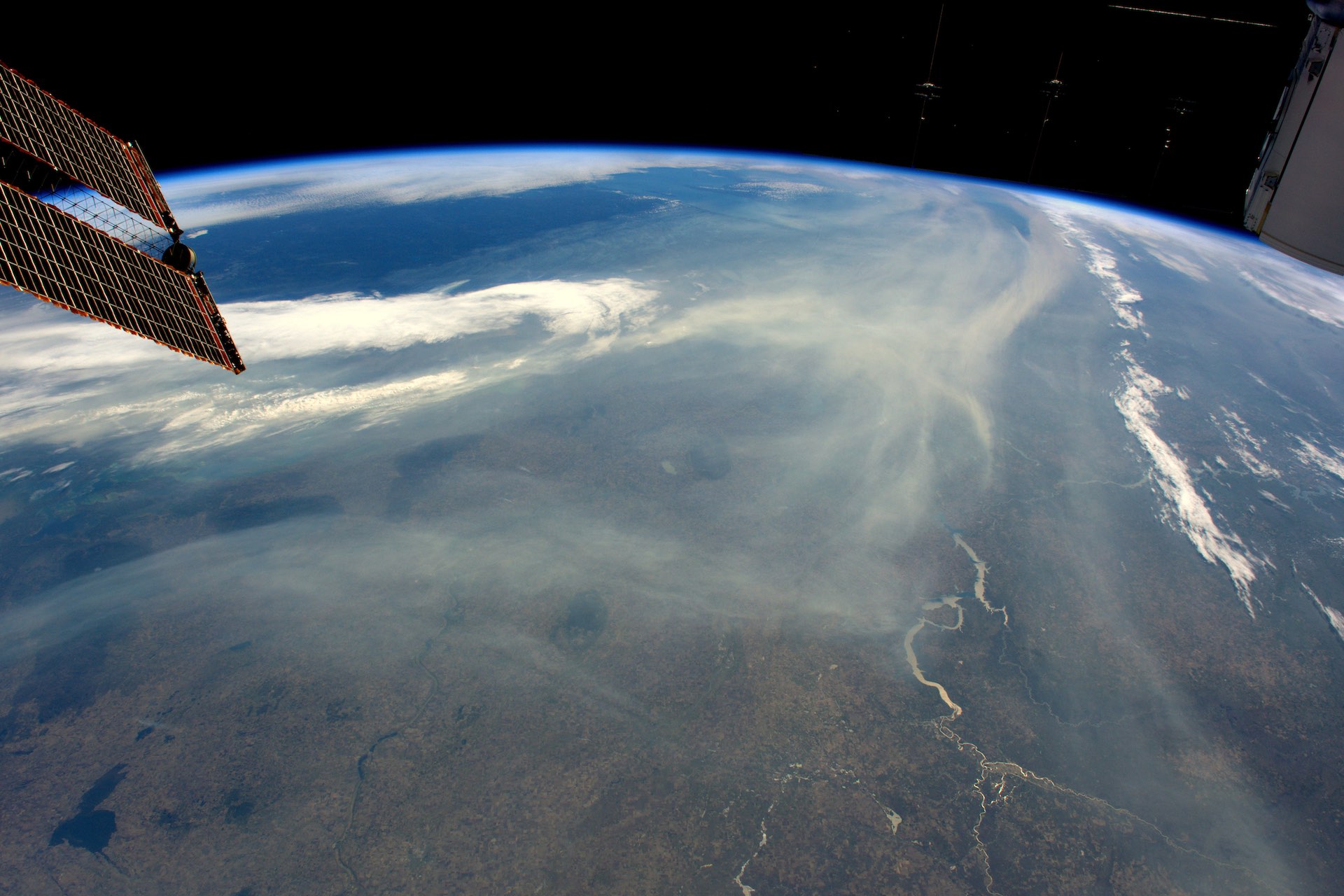
But north of Edmonton there’s still a whole lot of Canada. The satellites are lower in the southern sky there, beaming their signals on a slant through more atmosphere. Sometimes just a couple of signals might get through.
In the high Arctic, Horner says, you’ll be lucky if GPS can tell you where you are to within 100 metres. Weather, time of day and the locations of the satellites at the critical moment can worsen that to as much as a kilometre.
GPS isn’t the only satellite-based navigation system (the name applies specifically to the U.S. iteration). China, the European Union and Russia each have their own in addition to the American version, beaming down GPS-like signals. In fact, Russia’s satellites reach latitudes of nearly 65 degrees, meaning they’re better in the Arctic than GPS is.
“There are sovereignty, security and economic prosperity aspects to ensuring the North is Canadian-defended and deterred against,” Horner says. That means thinking about better alternatives to the positioning and timing systems we depend on.
Xona, an American navigation company, is aiming to supplant all those government-run systems with a private one that delivers better service without a national agenda, says co-founder and chief technology officer Tyler Reid.
“We’ve ended up in a place where the largest consumers of GPS are the commercial industry folks,” Reid says, “but they’re not the ones driving the requirements.”
Reid, a Canadian educated at McGill University before going to Stanford for a master’s and PhD and working on autonomous vehicle technology for Ford, opened Xona’s office in Montreal in 2024. It now has about 15 of Xona’s roughly 100 staff.
In business since 2019, Xona plans to launch a low-orbit constellation of satellites that do generally what GPS satellites do, but with many more beams at higher power, plus authentication protocols to foil spoofing. The constellation is to include satellites in polar orbits.
GPS can tell you what road you’re on, most of the time; Xona aims to locate you to a point more precise than the width of a line of road paint. One Xona satellite is in the sky now; a few weeks after its launch in June 2025, the company raised US$92 million to send up more.
Reid reckons navigation technologies are on the verge of a step change equivalent to the shift from navigating by the stars to using terrestrial radio transmissions, or the advent of GPS itself.
Sovereignty concerns might be a fresh push, but commercial imperatives were already driving it, he says. “There’s a plethora of new technologies coming along to support that next order of magnitude, and investment in new infrastructure to do it.”